Accurate Projection Mapping..
There are 3 main ways to do accurate projection mapping.
The very expensive way - a LIDAR laser scan of the building and a 3D based media server such as Disguise
The difficult way - drawing onto the building through the projector with an app like photoshop - usually means being outside all night
and then there is the way I do it..
Work from a photograph taken from the projector position.
I invented this approach myself back in the days when I used to do building projections with slides and needed to get it right first time every time. Sometime in the early 1990s if I remember rightly.
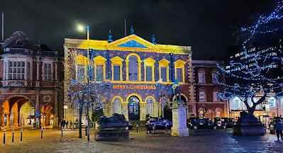
So here’s a brief walk though of the latest mapping project that I did for EMF onto a town hall in the UK
First, photograph the projection surface from the projector position
To get this photo, I had to put the camera on a light stand and wind it up to 20ft - the final position of the projector on a scaff tower in the square..
I then pop the photo into photoshop and make a template that acts as a map for all the content and I also use to generate a line up for the individual projectors. In this case using a 1920 x 1080 pixel template that matches the native resolution of the projector.
Then you just do all the content - I drop the .psd template into after effects and do everything there..
finally I generate a lineup - using the original photo + find edges, invert & levels. which is projected back onto the building to bring the projected image into a perfect fit for the actual building..
Of course there is bound to be a small amount of final adjustment but it’s usually just an inch or so off - all down to manufacturing tolerances in projector lenses, accuracy of projector placement and so on. I use Resolume Arena for playback. On this particular job the lower centre was off by around 4" so it just needed a tiny nudge in advanced output. If you can't afford Resolume, take a look at Qlab, which is free so long as you don't save, or you can rent it by the day.
here’s the end result..
Playback Resolume Arena


